YAMDENA EXPEDITION: A QUICK BASELINE SURVEY FOR CONSERVATION IMPLEMENTATION
By Amkieltiela
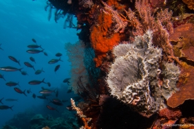
Water territories in Eastern Indonesia are renowned for its beautiful scenery and wide ranges of marine biota. Unfortunately, the beauty is currently threatened due to various destructive fishing practices. Bentang Laut Sunda Banda (BLSB), for example, is located at the heart of coral triangle and boasts significant marine resources. This region covers most of Eastern Indonesian areas such as Bali, West Nusa Tenggara, East Nusa Tenggara, South Sulawesi, Southeast Sulawesi and Maluku. These areas have one thing in common, they all rely on marine resources for their main income. This expedition was conducted to obtain information on how to improve community based management and conservation in Maluku. This article tells the journey of the second team of the survey of Inner Banda Arc Rapid Assessment series. The team consists of West Southeast Maluku District Marine and Fisheries Department and Pattimura University with a total of nine person: James Abrahamsz, Pieter Soselisa, Frederik W. Ayal, Wellem R. Sihasale (Pattimura University), A.P Sabono, Daniel Fanumby (Maluku Marine and Fisheries Department), Jan Manuputty, Amkieltiela, Reffa Pitaloka and Irvan Ahmad Fikri (WWF-Indonesia). Yamdena Island is the biggest island in Tanimbar island chain with a total area of 3,333 km2 and boasts 40 villages which are located within the shoreline. Because of limited time, we decided to choose 8 villages that represents the island as a whole: Lorulun, Batu Putih, Pulau Seira, Makatian, Ritabel, Sofyanin and Kelaan. The selected villages were recommended by the local Marine and Fisheries Department and Pattimura University who have deep knowledge of the island.
The team collected secondary data on social and ecological condition provided by local government and other sources in West Southeast Maluku District. Other datas include primary data related to utilization, management and governance system on marine resources in the local level, along with on-field data to validate the image of marine habitat distribution. Primary data was conducted using an in-depth interview and Focus Group Discussion consisting of village profile and customary governance to key informants such as local leaders to map particular locations where marine resources being exploited and also other important locations (customary land, sacred areas, sasi areas, etc).
As we stepped our foot in Saumlaki, the team directly went to the local Marine and Fisheries Department office to meet the head of the local office to gather secondary data. After that, the team took some data in Lorulun which was located within Saumlaki. The team was welcomed with local ceremony done by the local elders to wish the team good luck when conducting the sampling. The elders gathered in some traditional house to pray and the ceremony was closed with drinking the sopi by all participants.
Sopi is a traditional drink made from local plant called “Mayang Enau” or commonly known as sweet palm (Arenga pinnata). The name comes from Dutch language “Zoopje”, which means liquid alcohol. The process is rather simple using traditional tools. The juice extracted from Mayang Enau is placed in a bowl made of bamboo, and then the distillation changes the juice into what we called “sopi”. The process of making a sopi could take up to 10 days.
The team then continued their trip the following day to Batu Putih and Seira in the same day. The activity in Batu Putih was our shortest visit. As we got in the village, the head of village gathered his people to conduct FGD, while the rest of the team conduct an interview. Before moving to Seira, one of the village people came to us and gave us a very delicious salted fish. Being privileged by such treatment, we eventually gave her money in return as a token of gratitude although she refuses at first.
The trip to Seira is not as smooth as we have imagined, heavy rain almost hampered our speed boat. But finally our boat reached Seira safely, and it was a unique experience! Although consists of of five villages (Kamatubun, Weratan, Temin, Rumah salut & Welutu) the people are living in harmony with each other. The hospitality is also shown through by all the people in Seira Island. Apparently the young people like their picture to be taken, everytime we hold a camera, they always call on us to get their picture taken. Amusing, come to think of it.
Next up is Makatian and Ritabel. This time the weather was kind on us, the team could clearly see the panoramic view along the Seira-Makatian trip. Ritabel was our village to stay the night in order to collect data from Kelaan and Sofyanin. We met Mbak Vera here, a Surabayan who is an owner of a local restaurant. She has a dream to develop her restaurant business with moving to Bali. Her restaurant is our place to eat during our stay, and she was also a source of information for the surrounding communities and fisheries companies located in Ritabel.
The trip back from Kelaan to Ritabel was done through land because the speed boat has to be returned back to Ritabel in order to avoid low tide. In the following day, the team continued to Sofyanin. When FGD is taking place, a debate took place between the communities and almost led to a fight, but thankfully it can be resolved by the team with the help of head of village.
The team then went back to Ritabel, but didn’t forget to stop by in Nukaha. The Nukaha Island is as beautiful as paradise, its white sand and crystal blue water is capable of refreshing our exhausted minds. After a while, the team eventually got back to Ritabel to rest before continued on to Saumlaki and Ambon. The last data sampling was conducted in Skaru Kilimasa which was a reef cover data using manta tow method. The expedition was closed with thunder storm in our way to Saumlaki. What a thrilling experience!
Translated by Imanda Pradana