RAPID MAPPING OF THE POTENTIAL OF SEIRA ISLAND, WEST SOUTHEAST MALUKU, WITH THE COMMUNITY
By: Frederik Peter Alan Batkormbawa (Yamdena MPA Site Representative WWF-Indonesia Inner Banda Arc Subseascape)
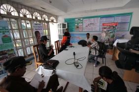
That morning, Tuesday (15/8/2017) the Directorate of Conservation and Marine Biodiversity (KKP), WWF-Indonesia Inner Banda Arc Subseascape (IBAS), Maluku Provincial Marine & Fisheries Office (DKP) conducted a joint rapid mapping on Seira Island, Wermaktian District, West Southeast Maluku Regency (MTB).
This joint rapid mapping is a data and information retrieval process that involves active participation of residents as information providers. Not just visual and written documentation, this mapping aims to support data - data analysis of an area map of the area.
The joint rapid mapping on Seira Island has an even greater goal, namely as a step in determining the management plan and zoning of the Marine and Small Island Conservation Area (KKP3K) of the Small Island Park (TPK) of West Southeast Maluku.
Seira Island is part of Wermaktian Sub-district - in addition to Wermatang Village, Batu Putih, Marantutul Village and a cluster of islands such as Selu Island, Wuliaru, Yeyaru, Kiswu, Nusnitu Island, and several other islands. Seira Island has five villages: Weratan, Temin, Rumah Salu, Welutu, and Kamatubun. The location of these five villages is close together on the north coast of the island.
The majority of people work as farmers and fishermen. "During the west wind season, people choose to do gardening, but during the east wind season, people go back to fishing," explained one Temin villager.
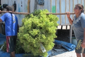
The coast of Seira Island in the east, south, and west are covered by high-density mangroves, muddy, and have seagrass beds in some spots. Meanwhile, the northern part of Seira Island has white sand and rocky cliffs. The community cultivates seaweed on the north coast of the island, due to suitable water currents and salinity conditions.
In terms of fishing, in addition to simple fishing gear, the community also uses floating cages and fishing cages in the western to northern part of Seira waters. Squid and puri fish are abundant on the coast of the island, so whale sharks often appear in its waters. Endangered, Threatened, Protected (ETP) biota such as sea turtles, dugongs, and dolphins use this area as their migration route and feeding area.
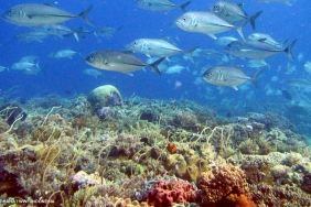
The extensive coral reef cover that is in good condition makes the Wermaktian water area has a varied reef fish population. Sakuda, snapper, baronang, skipjack, grouper, lobster, and shellfish dominate Wermaktian waters.
Sea cucumbers and lola are the main marine products Seira Island is famous for. On some of the island's coasts, these two commodities are protected through "sasi", the restriction of resource utilization through prohibiting the taking of marine resources for a certain period of time.
The people of Seira are quite aware of the potential of their area. Beginning to realize the importance of conservation, they were cooperative in jointly developing the area map and activity calendar in this rapid mapping.
The map of the area is important, to provide the position and relationship between various physical conditions and phenomena that occur in the community space. By placing the community as the main source of information, a lot of specific or distinctive information of Seira Island is expected to be revealed - things that may escape the observation of outsiders.